Africa’s Most Absurd Colonial Borders
At first glance, Africa’s borders can look oddly artificial — and that’s because many of them are.
Unlike Europe or Asia, where mountains and rivers often define boundaries, large parts of Africa were divided using rulers and ink. The result? Borders that slice through deserts, split cultures, and create geographic absurdities that still shape the continent today.
📏 Lines Drawn With a Ruler
Look at a map of North Africa and you’ll notice something striking: perfectly straight borders stretching across thousands of kilometers.
Countries like Libya, Chad, Niger, and Sudan are separated by lines that ignore geography entirely. No rivers. No mountains. Just coordinates.
These borders were drawn in European capitals, often by people who had never set foot in the regions they were dividing.
🏛 The Berlin Conference: Dividing a Continent
The roots of these strange borders lie in the Berlin Conference (1884–1885).
European powers — including Britain, France, and Belgium — gathered to divide Africa among themselves. There were no African representatives present.
Instead of considering ethnic groups, trade routes, or ecosystems, they focused on control and access.
What followed was the infamous “Scramble for Africa.”
🌍 One People, Many Countries
One of the most lasting consequences is the division of entire peoples.
The Somali people, for example, were split between Somalia, Ethiopia, Kenya, and Djibouti. Borders cut across traditional lands, disrupting migration routes and social structures.
This fragmentation has contributed to conflicts, including the Ogaden War, and continues to influence regional tensions.
🐍 A Country Shaped by a River
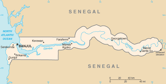
Then there’s Gambia — one of the strangest shapes on the map.
The country follows the Gambia River, a direct result of colonial rivalry between Britain and France. The British controlled the river; the French controlled the surrounding land (modern-day Senegal).
The border was drawn based on how far ships could sail inland.
The result? A country barely wider than the river it follows.
🏜 A Border That Created No-Man’s Land
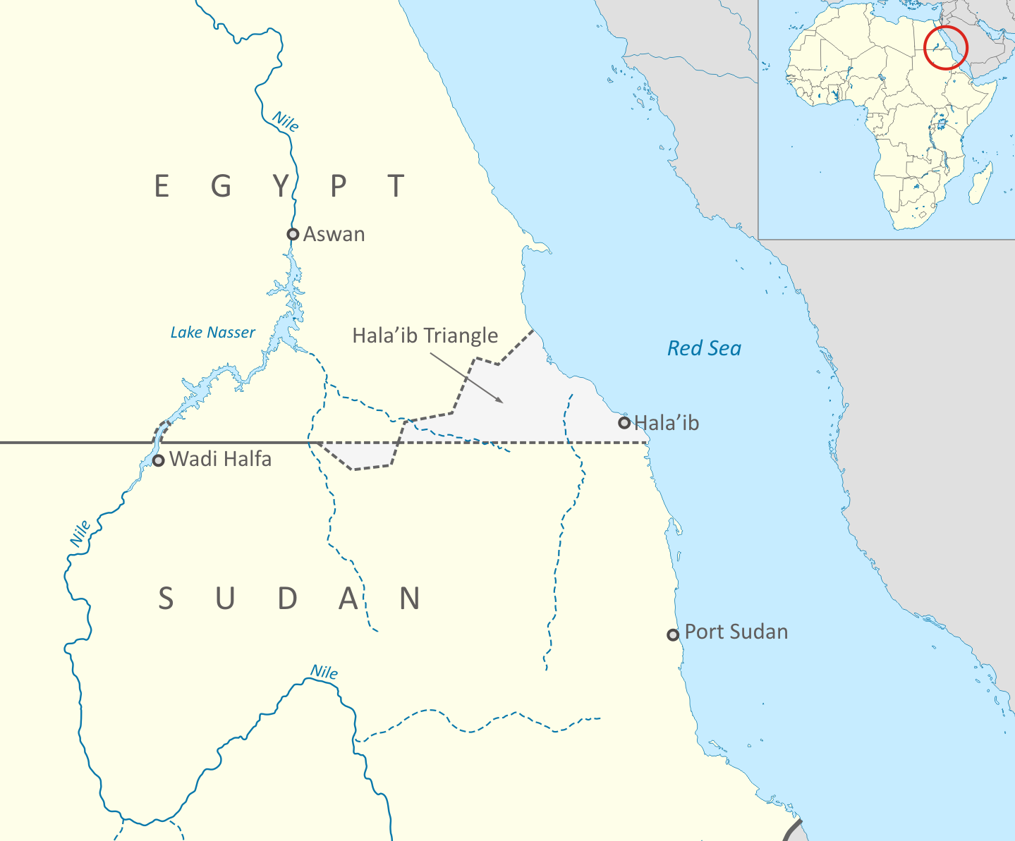
Some borders are so arbitrary they created places that no one wants.
Between Egypt and Sudan lies Bir Tawil, one of the only unclaimed pieces of land on Earth. Both countries prefer to claim a different, more valuable area nearby — the Hala’ib Triangle.
The result is a geopolitical anomaly born entirely from conflicting colonial-era borders.
⚠️ Borders That Still Matter
These lines may have been drawn over a century ago, but their impact is very real.
They influence:
- Conflicts and political tensions
- Migration and identity
- Economic development
- Regional cooperation
Africa’s map is not just geography — it’s history, power, and consequence.
✈️ Why This Matters for Travelers
For travelers, these borders tell a deeper story.
They explain why:
- Cultures don’t always match country lines
- Languages shift unexpectedly across borders
- Some regions feel more connected to neighboring countries than their own
Understanding these lines adds a new layer to how you experience the continent.
💡 Next time you look at a map of Africa, don’t just see countries — see the lines, and the stories behind them.
Leave a Reply